Hello, January! Storm could drop up to 7 inches of snow
It’s been a temperate January by southern Minnesota standards, but the switch will flip over the next three days.
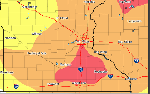
The National Weather Service says a winter storm with snow and strong winds will impact the region late Wednesday through Friday.
The most intense part of the system appears poised to strike Waseca County, a large swath of Blue Earth County, and southern Le Sueur County. Mankato is on the line between “high” and “medium” storm impacts. NWS lists Nicollet, Watonwan, Brown, Martin, and Sibley counties at medium impact risk.
A mix of rain, snow, and freezing rain will begin in the overnight hours of Wednesday, becoming all rain early Thursday with some snow mix, but little potential for accumulation. NWS warns that ice glazing could be an issue on Minnesota roads on Thursday morning.
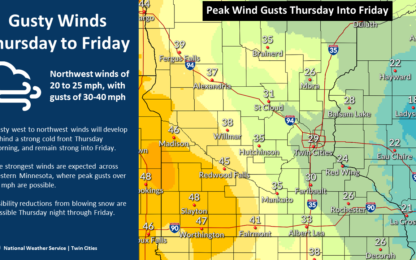
Thursday temperatures will remain in the low 30’s, even overnight, but gusty northwest winds will cause patchy, blowing snow, affecting nighttime travel. Peak winds gust in the Mankato area should hit about 35 miles per hour, while areas to the west are looking at more intense winds.
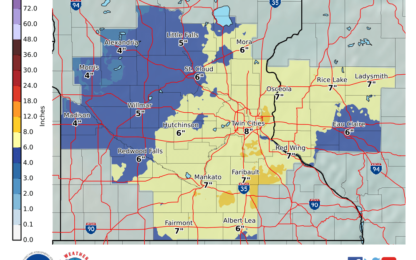
In Mankato, snow is expected to start Thursday morning around midnight, continuing all of Friday with blustery conditions. A total of 7 inches is expected to drop in the Mankato area.
The storm will exit by Saturday morning, leaving mostly cloudy skies with highs in the mid-20’s.
Popular Stories
Recent Stories